


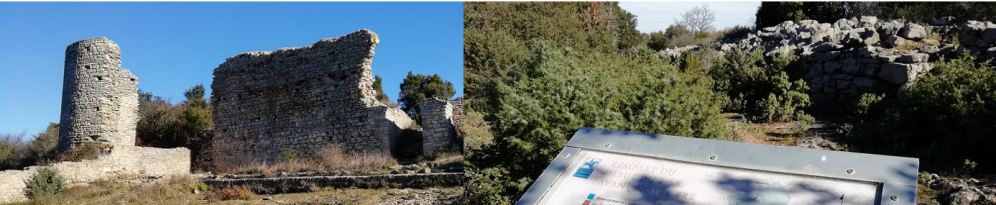
Located at a bit more than 25 km from Uzès, the "camp of César" overlooks Laudun-l'Ardoise from its rocky spur.

Oksana Leprince et les aventures d'Ofelia... en un clic !

The Distinguished Gentleman's Ride... en un clic !

Les fraises... en un clic !

Cœur de villages, la dynamique des petites communes... en un clic !

A bicyclette sur la ViaRhôna... en un clic !

Virée à l'Espiguette...

L'Ecrin, l'adresse du prêt-à-porter à Uzès

Visite au moulin Fabre Joybert... en un clic !

Les Monuments aux morts du Gard... en un clic !
Being part of the numerous ideas of hikes suggested "along the banks of the Rhone, the Cèze and the Tave" the archeological site, that one can reach following a path crossing the forest of pines and oaks also offers, from its belvederes, an unobstructed view on the region of the Rhone Gard and the vineyards of the Côtes du Rhône.
VISIT
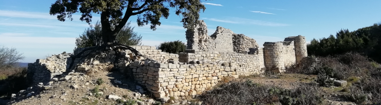
Excavated since the 19th century, the site of the oppidum* covers several hectares. From the first ramparts to the postern and the tower, from the main Roman gate to the foundations of the forum and the basilica, Caesar's camp can be seen like an open book.
|
Did you know that? Caesar's Camp, which stands on a barred spur like the one of Saint-Pierre-de-Castres (Tresques), is one of the largest fortified high sites in southern Gaul, with an intramural area of 18 ha. Only the site of Castellas in Murviel-lès-Montpellier is larger, with 20 ha*.
|
If the excavations undertaken by the heritage department of the municipality of Laudun-l'Ardoise in collaboration with the Ministry of Culture have made it possible to date the period of occupation of the oppidum from the 5th century BC to the 6th century AD, they have also made it possible to note that "an extremely dense and well-preserved urban plan" underlined the importance and richness of the site, while the "vertical cliffs that surround it offered a natural defense on the north, east and south sides".
|
"The oppidum occupied an eminently strategic position on the edge of the Rhone and at the confluence of the valleys of the Cèze and the Tave. It commanded access to the roads leading to the Cevennes and the upper Rhone Valley. In addition, it benefited from the proximity of two major Roman roads: the Domitian Way linking Italy to Spain and crossing all of southern Gaul, as well as the Helvian Way between Nîmes and Alba-la-Romaine. (Town hall of Laudun-l'Ardoise, Tourism and Heritage section) |
The defensive towers leaning on the ramparts are difficult to observe today. However, the various panels which punctuate the visit give a rather precise idea of the structure of the camp which, from the first Iron Age to the agglomeration of the 1st century B.C. and to the Augustan period (time of the construction of a new rampart), did not cease to grow and to prosper, politically as well as economically it seems, with the construction in the High-Empire of the forum of the basilica.
Also to be discovered, the Romanesque chapel of Saint Jean de Rouzigue (+- 11th c), formerly called Saint Jean de Todon, which rises a little further on the plateau of Lacau.
|
Todon" reminds us of the priory depending on the conventual priory of Saint-Pierre de Pont-Saint-Esprit, attached to the abbey of Cluny.
|
The church of the order of Cluny, the object of a dozen archaeological excavations since 2002, consists of a nave closed by an apse. The origins of the building, measuring a little more than 24 m long and 8 m wide, date back to the 5th and 7th centuries. Facing the entrance of the church, a small necropolis (9th-13th centuries) reveals some tombs. Following the excavations, "200 were discovered, including 141 anthropomorphic forms".
The steep edges of the rocky massif, where the lookouts are located, also allow you to discover the surprising passage of the wolf (passage du loup), a thin tear in the rock about 27 cm wide, which shelters a path to go back down to Laudun. Notice to the amateurs of strong sensations.
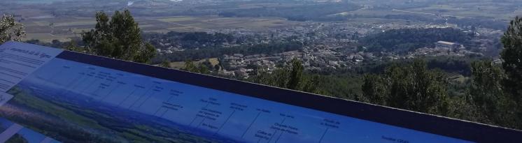
Two choices are offered to the walkers after having enjoy the unique point of view on the area and on the Rhone, which one sees snaking at a little more than 4 km from there: To follow one of the paths which traverses the scrubland and join the other side of the rocky promontory to see the green landscape, or return on the camp of Caesar. There, it will be possible to push towards the ramparts of the 1st century B.C., marking the western limit of the ancient city, "a defensive structure in dry stones of Gallic tradition, with an average width of 4 m and extending over some 350 m long".
Sources, readings : * Article by Dominic Goury " L'oppidum du Camp de César à Laudun " : premières acquisitions de la recherche 1990-1994 " (Revue archéologique de Narbonnaise, 1997), **article by Yann Ardagna, Delphine Blanchard, Elie Pélaquier et Laurent Vidal Aux marges de l'ancienne agglomération antique du Camp de César : Saint-Jean-de-Todon alias Saint-Jean-de-Rousigue published in l'Archéologie du Midi Médiéval (2010).